the Forum for Moutain and Map(FYAMAP)
 Technical Terms
the Forum for Moutain and Map(FYAMAP)
'the Forum for Moutain and Map' is a forum (digital confarence) in NIFTYSERVE (the largest PC conference), established in October 1994.The origin of our forum was a group whose member like prospect for mountains. Now theme of our forum is up to nature, culture, muntaineering and information of climbing moutains.
We have been interesting in maps that is necessary for mountaineering, our interest is not only in moutain map but also in maps in general. There is few forum about map, so our forum is necessary for men and women who like map. One of our forum conference is operated by a member of Japan Map Center (Suplyer of Maps provided by Geographic Survey Institution of Japan).
One of charactaristic of our forum depended on computers is members who are interesting in developing softwares. They have been developing softwares about maps and moutains, and also making various data of maps and moutains.
A character of moutain in Japanese, 'Yama' has three peaks. Like this character our forum also has three peaks-- mountains,maps and softwares.
This comment is originaly written by Mr. Tashiro who is a representative partner of our forum, and translated into English by me.
The detail of relations about me and the forum is here, but it is written in Japanese, sorry.
BOOK 'The Encyclopedia for viewing Mt.Fuji'
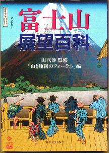 The second publication of 'FYAMAP', 'The Encyclopedia for viewing Mt.Fuji' will be soon coming out from The Jitsugyo-no-Nippon-sya. Its price is 2,200yen + tax. 29 FYAMAPPer (members of 'FYAMAP') wrote this book. I wrote about viewing Mt. Fuji from a window of train on 'Odakyu Tama Line' and 'Keio Sagamihara Line'. As this book being sold, with I get not so mach a royality on this book, but I want you to buy this book!
It contais 32page of Photogravure!
The body is follow.
- Viewing Mt. Fuji
- Sticking to the way of viewing Mt. Fuji
- Taking a picture and Making Mt. Fuji
- Keeping on viewing Mt. Fuji
BOOK 'Enjoying Moutains and Maps with a personal computer'
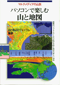
The first publication of 'FYAMAP' , 'Enjoying Moutains and Maps with a personal computer' came out from The Jitsugyo-no-Nippon-sya. Its price is 2,000yen + tax. I wrote about 'Vistapro', as this book being sold, with I get a royality on this book, so you should buy this book!Part 1 of this book, Interpret of mountains and maps by the use of PC is written. And recent situation about maps heading for digitalization including digital map.
Part 2 of the book, explanations for the softwares contained in 'FYAMAP CD-ROM' is written.
If you are interesting in maps and mountains, this book ia a good handbook for you, but it is written in only Japanese.
CD-ROM 'Enjoying Moutains and Maps with a personal computer'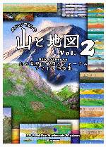
When the first anniversary of 'FYAMAP', in October 1995, our forum isseued CD-ROM title. It contains many softwares and images of computer graphics and data. It collects big size movies, so you are not necessary to download softwares from host library, its advantage.
The beginning of the issue, it didn't sell well, but from November 1995 on, it sold well, because of its low price and a lot of collected data. We often heard the title get the top of sales ranking, the title finally sold 26,000 titiles, its a big hit title.And next CD-ROM titile was isseued on November 1996, the second anniversary of our forum, this titile was reinforced titile. This title is much better than first titile.
This title contains 3 times as many as photos, and computer graphics is much detailed than used be. And you can easily appriciate all of them with a web browsing software contai contained in this CD-ROM, (I wrote the html in this titile, so it's simple!) Movies in this CD-ROM ocupied 100MB, and a movie for useing this title is contained, A manual text for using the title is not so bad. (I wrote the manual text, so it's not so nice....but not so bad.)
And a computer graphics generated by me! is a one of components painted in title packege.
- TITLE: Enjoying Moutains and Maps with a personal computer--volume 2
- Date of issue: 1996/10/18
- Price: 2,800 yen + tax
- Provided by Inter Limited Logic co.Ltd
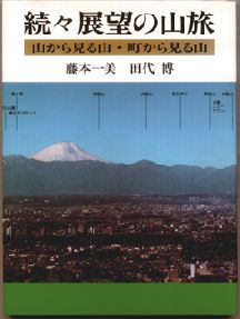
BOOK 'Travelling mountains for viewing''Travelling mountains for viewing (1st, 2nd, 3rd Edition)' is a first pubication , in Japan, for collecting picutures that draw view from mountain and that explain what moutain can view.
One of authors of this book is Mr. Tashiro who is a representative partner of our forum, and he is a high-school teacher, then we call this book, what you call, 'The manual for viewing'.
The 3rd editon pubulished on 1995 was completed thank to the united efforts of a great number of members of 'FYAMAP' (except me).
Looking in steroscopic
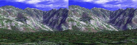
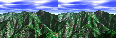
Looking in steroscopic is one of enjoying ways for prospective photographs.
It is easy to take a stereoscopic photogarphs, if only you can move right or left 1/100 as much as distance between from object point and current locatin.
For example, if your destination is 20km away from your location, you should move 200m. It's easy to move 200m in a wide peak of moutain. Although you can't move enough, if you find a peak in front of target peak, it is alternative. A length to move depends on a distance from you to the alternative peak.
The way of looking stereoscopic is 'way of parallel look' and 'way of crossing look'. Way of crossing look is easy to do for me. You must two eyes move to center, then two images approching each other, finally two images come to one image, so you can look a stereoscopic scenary.
Of course you can get stereoscopic CG by Kashmir and Mov. (sample above)TRY looking in stereoscopic by VERDE.
COMPASSGLASS
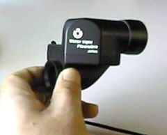
Compass-glass is a necessary tool for viewing mountains. It is composed by compass and telescope. If you look into front side of scope, you will see a compass in front of object peak. And you can read angle of digree of target peak 1 degree by 1 degree. Its size is small, so you can put it in your pocket or suspend it from your neck.
If you asked by someone at the peak, "Where can I see Mt.xxxx?", then you take a compassglass and glance at the peak and read the digree, so you lend a compassglass to him and you may say,"A peak angle of 78 digree may be." as if it were incidental!
This tool is originally made for shipman, you can get this special goods at following.
- Provider:ISHII-SEISAKUSHO
- Location:Syakujii 1-37-13, Nerima,Tokyo,Japan
- Phone and Fax:81+3+3928+5411
Digital map
Digital maps are digitalized maps from printed maps issued by Geographic Survey Institution of Japan. For use of simulating view mountains, 50m &250m Grid (Elevation) Data is best solution.
following sentence is a quotation from 'FYAMAP Japan Map Center web site' about 50m grid.
This data is DEM Data taken from contours of 1:25,000 topographical maps. Compiled topographic map of 1:25,000 boundary is 7'30" in longitude direction and 5' in latitude direction. This area is known as Secondary Mesh area. This area is divided into 200 grids (recorded in W-E and N-S order) and central elevation data of each grid is recorded. The grid interval is 2.25 second in longitude direction, and 1.5 second in latitude direction.
Therefore the grid interval is about 50m. Elevation data recorded in 0.1m (=10cm) unit.
One floppy disk has a file of one topographical map sheet.
At present (Feb,96) 50% of total of Japan is being published. We are hoping to complete whole of Japan's publication by 1997.
One peace of Floppy Disk used be contain 1 topographical maps, and its price used be 9,700 yen!!
But in 1997, CD-ROM map was issued, its price is only 7,500 yen.
And it collects 2100 as many as FD version.
Its price reduced 1/3000!!.
It was a biggest price cut I have heard!!
Softwares